Chip Sealing Sterling Heights Michigan
We Are Locally Owned
& Operated For 36 Years
Contact Us Today!
About Chip Sealing
Introduction
Access the best in durable, cost-effective pavement solutions with Chip Sealing. As a commercial property owner or manager, it’s crucial to have a reliable paved surface, like a driveway or parking lot – a space that is both visually appealing and functional. Chip sealing is a popular method, one that brings several advantages to table such as heightened durability, ease of maintenance, and aesthetic flexibility. This comprehensive guide will cover the process, benefits, and practicality of chip sealing on commercial properties.
What is Chip Sealing?
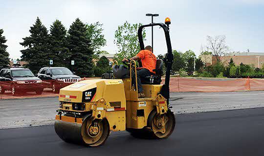
Chip sealing is a pavement surface treatment that combines one or more layer(s) of asphalt with one or more layer(s) of fine aggregate. This treatment has been well-recognized in the paving industry due to its longevity, cost-effectiveness, and aesthetic value.
The Process of Chip Sealing
The process of this pavement treatment involves a simple, yet effective series of steps. Firstly, a hot liquid asphalt is applied on the surface of the area that needs treatment. This serves as a binder, ensuring that the entire surface will adhere perfectly and securely on the road. The next step involves spreading a layer of chips or gravel on top of this binder. These chips are then rolled into place to ensure they stay firmly embedded. This general process creates what is commonly referred to as a ‘chip seal driveway’ or ‘chip and seal driveway’. It is one of the preferred methods used by tar & chip driveway contractors, largely because it prevents deterioration and extends the lifespan of the driveway.
Benefits of Chip Sealing
One major benefit of chip seal paving is its durability. It acts as a protective shield, shielding the driveway or similar paved areas from the damaging effects of heat, snow, rain, and heavy loads. Sealing chips are known for their resistance to extreme weather conditions, making it a highly practical choice for commercial properties. In addition, a chip and seal driveway require less maintenance compared to other driveway materials such as pure asphalt or concrete. The binder used in chip sealing prevents cracks, reducing repair costs.
Another key benefit of chip seal paving is its cost-effectiveness. Installation costs tend to be significantly lower than for other paving methods. The minimal maintenance that chip seal driveways require also contributes to this cost-effectiveness. In other words, these driveways offer exceptional quality and performance without giving away your budget.
In terms of aesthetics, chip sealing offers more than just a smooth, durable surface. The architecture industry widely appreciates the natural beauty of a chip and seal driveway. There is a wide range of chip types available, from different sizes to different colors – thus allowing customization to match the design and ambience of the commercial property.
Choosing the Right Tar & Chip Driveway Contractors
Choosing the right contractor for chip seal paving can mark the difference between a long-lasting, low-maintenance driveway and one that deteriorates quickly. In choosing the right contractor, it’s important to look for experienced professionals who have an outstanding track record in delivering high-quality chip and seal paving services.
Consider things like repertoire, customer reviews, and years of experience. The right contractors can provide portfolios of their previous work, allowing clients to see if their quality and style aligns with exactly what you have in mind for your commercial property.
Conclusion
Chip sealing is a tried and tested paving option that delivers strength, durability, and cost-effectiveness. As a commercial property owner or manager, investing in a chip seal driveway or any chip sealed paving area can translate into significant maintenance savings and curb appeal enhancement. This is why many turn to experienced tar & chip driveway contractors to ensure the job is done right the first time. This comprehensive guide should arm you with the necessary knowledge to make an informed decision about chip seal paving for your commercial property.
Still have questions or need professional advice about chip sealing? Don’t hesitate to reach out to experts in your city or region. With their help, you’ll have the most suitable and efficient solution tailored to your commercial property’s unique requirements.
Contact Us Today for a FREE
Chip Seal Quote


About Sterling Heights, Michigan
History
As a result of the War of 1812 and the 1817 Treaty of Fort Meigs, the area of the Michigan Territory which now makes up Sterling Heights was first surveyed by Deputy Surveyor Joseph Wampler; his survey was approved on February 20, 1818. Wampler had been one of two deputy surveyors of Perrysburg, Ohio, in 1816.
Originally created as part of Shelby Township in April 1827, it was broken off as Jefferson Township in March 1835. In March 1838, it was renamed Sterling Township.
Until the 1950s, Sterling Township was an agricultural area, largely devoted to growing rhubarb and other crops sold in Detroit. Road improvements led to decreased commute times and lower costs for the delivery of goods and services to and from businesses. The population increased when suburban homes were built for the workers in metropolitan Detroit’s booming automobile industry. When Sterling Township was incorporated as a city in 1968, “Heights” was added to the name to satisfy a state law that prevents incorporated municipalities from having the same name, as there was already a small village named Sterling in Arenac County.
Gerald Donovan became the first mayor of the city and F. James Dunlop became the first mayor pro-tempore. In the 1960s and 1970s, many residents came to live in Sterling Heights to work in automobile plants operated by Chrysler and Ford. Lakeside Mall opened in Sterling Heights in 1976.
The city is home to many groups of immigrants. It has received many people of eastern European origins, including ethnic Albanians, Bosnians, Croatians, Macedonians, Montenegrins, Poles, Serbians and Slovenians. After the 2003 U.S.-Iraqi War, millions of Iraqi citizens were displaced, particularly Iraqi Christians (Chaldean Catholics and Assyrians). Of these, 30,000-50,000 resettled in Sterling Heights, giving parts of the city the nickname “Little Nineveh”, especially around 15 Mile Road and Ryan.
Geography
Sterling Heights is a second-ring suburb, 14 to 20 miles (23 to 32 km) north of downtown Detroit. The city’s southern border is 6 miles (10 km) from Detroit’s northern border. The shape of the city is six miles long and miles wide. It is bordered to the south by the city of Warren, at its southwest corner by Madison Heights, to the west by Troy, to the north by Utica and Shelby Township, at its northeast corner by Macomb Township, to the east by Clinton Township, and to the southeast by Fraser.
According to the U.S. Census Bureau, Sterling Heights has a total area of 36.72 square miles (95.10 km), of which 36.45 square miles (94.41 km2) are land and 0.27 square miles (0.70 km), or 0.74%, are water. The Clinton River crosses the northeast part of the city, flowing east to Lake St. Clair east of Mount Clemens.
Climate
Sterling Heights features a humid continental climate (Köppen: Dfa). Summers are somewhat hot with temperatures exceeding 90 °F (32 °C) on average 8.6 days. Winters are cold, with temperatures not rising above freezing on 39.1 days annually, while dropping to or below 0 °F (−18 °C) on average 1.2 days a year.
Neighboring cities/towns
Main highways
Sterling Heights sits on two main thoroughfares:
State highways
 M-53 commonly called Van Dyke Avenue or the Van Dyke Freeway (they split in the city, however, and rejoin to its north), which leads north into The Thumb of Michigan.
 M-59, commonly called Hall Road once the freeway ends—which is the east–west connector from just north of Mount Clemens, through Utica as a surface road, and then becomes a limited access freeway to Pontiac, being the main northern connector between Macomb County and Oakland County. In Sterling Heights, large areas are devoted to retail and commercial development (e.g., Lakeside Mall).
Other main roads
- Mound Road is an important north–south artery that runs continuously through the city. Overall, the road starts south in Hamtramck and runs up to 32 Mile Road in Romeo. The road ends briefly at River Bends Park in Shelby Township (becoming Auburn Road), and continues just north of 22 Mile Road.
- East-west travel is mainly on the “mile roads,” beginning at 14 Mile Road through 20 Mile Road (M-59). 16 Mile Road, also known as Metro Parkway, is another major “mile road”. See Roads and freeways in metropolitan Detroit.
- Utica Road is an important diagonal connector that crisscrosses the city from southeast to northwest, going through the intersection of Dodge Park Road (across from the Sterling Heights city hall) via the first roundabout in Macomb County.
- Dequindre Road is the border between the city of Sterling Heights and the city of Troy. It is also the border between the counties of Macomb and Oakland.
- Hayes Road is the divider between Clinton Township (Between Utica Road and South of M59) and Fraser (Between Masonic and Moravian).
Demographics
| Census | Pop. | Note | %± |
|---|---|---|---|
| 1940 | 3,648 | — | |
| 1950 | 6,509 | 78.4% | |
| 1960 | 14,622 | 124.6% | |
| 1970 | 61,365 | 319.7% | |
| 1980 | 108,999 | 77.6% | |
| 1990 | 117,810 | 8.1% | |
| 2000 | 124,471 | 5.7% | |
| 2010 | 129,699 | 4.2% | |
| 2020 | 134,346 | 3.6% | |
| U.S. Decennial Census 2018 Estimate |
|||
2020 census
| Race / Ethnicity (NH = Non-Hispanic) | Pop 2000 | Pop 2010 | Pop 2020 | % 2000 | % 2010 | % 2020 |
|---|---|---|---|---|---|---|
| White alone (NH) | 111,743 | 108,750 | 106,149 | 89.77% | 83.85% | 79.01% |
| Black or African American alone (NH) | 1,602 | 6,638 | 8,709 | 1.29% | 5.12% | 6.48% |
| Native American or Alaska Native alone (NH) | 239 | 246 | 200 | 0.19% | 0.19% | 0.15% |
| Asian alone (NH) | 6,100 | 8,713 | 10,935 | 4.90% | 6.72% | 8.14% |
| Pacific Islander alone (NH) | 35 | 16 | 13 | 0.03% | 0.01% | 0.01% |
| Other race alone (NH) | 122 | 158 | 337 | 0.10% | 0.12% | 0.25% |
| Mixed race or Multiracial (NH) | 2,965 | 2,655 | 4,728 | 2.38% | 2.05% | 3.52% |
| Hispanic or Latino (any race) | 1,665 | 2,523 | 3,275 | 1.34% | 1.95% | 2.44% |
| Total | 124,471 | 129,699 | 134,346 | 100.00% | 100.00% | 100.00% |
2010 census
As of the census of 2010, there were 129,699 people, 49,451 households, and 34,515 families living in the city. The population density was 3,552.4 inhabitants per square mile (1,371.6/km2). There were 52,190 housing units at an average density of 1,429.5 per square mile (551.9/km). The racial makeup of the city was 85.1% White, 5.2% African American, 0.2% Native American, 6.7% Asian, 0.5% from other races, and 2.2% from two or more races. Hispanic or Latino of any race were 1.9% of the population.
There were 49,451 households, of which 31.0% had children under the age of 18 living with them, 55.0% were married couples living together, 10.5% had a female householder with no husband present, 4.3% had a male householder with no wife present, and 30.2% were non-families. 26.5% of all households were made up of individuals, and 10.7% had someone living alone who was 65 years of age or older. The average household size was 2.61 and the average family size was 3.20.
The median age in the city was 40.4 years. 21.7% of residents were under the age of 18; 8.8% were between the ages of 18 and 24; 25.8% were from 25 to 44; 28.6% were from 45 to 64; and 15.2% were 65 years of age or older. The gender makeup of the city was 48.5% male and 51.5% female.
2000 census
As of the census of 2000, there were 124,471 people, 46,319 households, and 33,395 families living in the city. The population density was 3,397.0 inhabitants per square mile (1,311.6/km2). There were 47,547 housing units at an average density of 1,297.6 per square mile (501.0/km). The racial makeup of the city was 90.70% White, 1.30% African American, 0.21% Native American, 4.92% Asian, 0.04% Pacific Islander, 0.34% from other races, and 2.50% from two or more races. 1.34% of the population were Hispanic or Latino of any race.
Ancestries: Polish (19.0%), German (14.4%), Italian (12.5%), Macedonian (5.7%), English (5.0), Chaldo-Assyrians (20.7%), American/US (4.0%) and Irish(4.0).
In 2000, there were more people in Sterling Heights born in Iraq than any other foreign country. In that year there were 5,059 people in Sterling Heights born in Iraq. The next three largest nations of foreign birth were North Macedonia at 1,723, Italy at 1,442 and Poland at 1,427. Now in 2020, there are an estimated 50,000 Chaldeans in the city.
There were 46,319 households, out of which 32.9% had children under the age of 18 living with them, 60.4% were married couples living together, 8.5% had a female householder with no husband present, and 27.9% were non-families. 24.1% of all households were made up of individuals, and 8.5% had someone living alone who was 65 years of age or older. The average household size was 2.66 and the average family size was 3.21.
In the city, the population was spread out, with 24.1% under the age of 18, 8.5% from 18 to 24, 30.4% from 25 to 44, 25.2% from 45 to 64, and 11.8% who were 65 years of age or older. The median age was 37 years. For every 100 females, there were 96.0 males. For every 100 females age 18 and over, there were 92.6 males.
The median income for a household in the city was $60,494, and the median income for a family was $70,140. Males had a median income of $51,207 versus $31,489 for females. The per capita income for the city was $24,958. About 4.0% of families and 5.2% of the population were below the poverty line, including 6.6% of those under age 18 and 7.5% of those age 65 or over.
Education
Sterling Heights is served by two public school districts: Utica Community Schools, which serves the northern half of the city, and Warren Consolidated Schools, which serves the southern half of the city. Utica operates two high schools in the city, Stevenson High School and Henry Ford II High School, while Warren Consolidated only operates one in Sterling Heights High School. Additionally, Parkway Christian School, a private K-12 Christian school, is also located in the city.
Contact Us Today for a FREE
Chip Seal Quote
Our Chip Seal services are available in Sterling Heights as well as all of Macomb County.
Our dedicated team at D&J Contracting Inc is at-the-ready to provide you with great customer service and first class Chip Seal services. Reach out to us at (586) 954-0008 to discuss your Chip Seal needs today!